Features Réso3D+
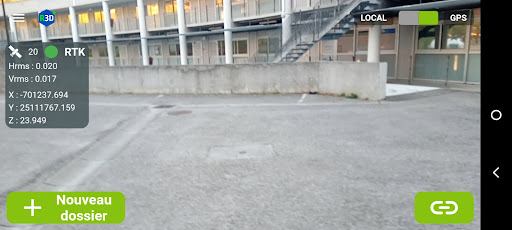
RESO3D+ is the application that allows you to geo-reference ENEDIS Class A networks and accessories.With Reso3D+, carry out your network measurements using direct georeferencing photogrammetry!Coupled with Reso3Ds GNSS, capture centimeter-precision images and obtain a georeferenced point cloud of the trench in just a few minutes.** FEATURES**- Capture georeferenced photos- Automated photogrammetric sending and processing- Export of point cloud and orthophoto- Cartographic deliverable to the Enedis Carto200 standard- Edition of a cubature report
Social Features
Connect and share with friends and the community.
Camera Features
Advanced camera features with editing capabilities.
Food & Dining
Discover recipes and order food from your favorite restaurants.
See the Réso3D+ in Action

Get the App Today
Available for Android 8.0 and above